Features of the Wādī Darbāt
Aim and introduction
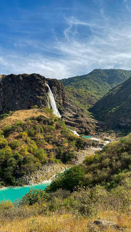
This is the second lesson in this series about the Wādī Darbāt and Kho Ruri and will explore the main features of a river with a focus on the Wādī Darbāt and the waterfalls. It will reflect on the knowledge of the features covered in Lesson 1 and develop understanding of the processes which create specific river landforms.
Curriculum links
Physical geography, including: physical geography, including: climate zones, biomes and vegetation belts, rivers, mountains, volcanoes and earthquakes, and the water cycle.
Learning goals
- Locate key features of a river profile.
- Show how waterfalls are formed.
- Know how processes can affect the formation of a waterfall.
Learning outcomes
Greater depth: pupils will be able to accurately label the main features of a river profile and show clear understanding of the processes which influence their creation. They will be able to accurately sequence the formation of a waterfall using Wādī Darbāt as an example. At the upper level, they will be able to explain how processes help create this landform. The geographical terminology used will be accurate and relevant to the topic.
Expected level: pupils will be able to label the main features of a river profile and show understanding of the processes which influence their creation. They will be able to sequence the formation of a waterfall and may use Wādī Darbāt as an example. Geographical terminology will be used, most of which will be accurate and relevant to the topic.
Working towards: pupils will be able to label most of the main features of a river profile and show some understanding of the processes which influence their creation, this may be inaccurate in places. The formation of a waterfall will be present but might not be complete and/or in sequence. Geographical terminology will be used with some accuracy.
Support: with guidance, pupils will be able to label most of the main features of a river profile, understanding of the processes involved may be limited or not present. The formation of a waterfall will most likely be out of sequence with inaccuracies. Limited geographical terminology will be used.
Key terms
- Hard rock
- Soft rock
- Limestone (for Wādī Darbāt)
- Erosion
- Plunge pool
- Undercutting
- Valley
- Seasonal
- Confluence
- Meander
- Source
- Mouth
- Topography
Learning resources
- Features of the Wādī Darbāt – Teacher Presentation
- Definitions of river features with images (see ‘resources; section in the teacher presentation).
- Wādī Darbāt sketch map.
- Formation of a waterfall diagram
What you will need
- Modelling supplies such as playdoh, plasticine, clay etc or small building blocks (e.g. Lego).
- Mats to protect tables (if needed)
Challenge and support
Challenge pupils to think about how the river features are formed.
Support pupils by adding text boxes to the features of the river to help them locate it.
Starter
Show an image of the Wādī Darbāt waterfalls on the screen. Get pupils to write down or say to their peers / class what they would think / feel if they were looking at this place for real. Get pupils to think about how this links to their previous learning on the Wādī Darbāt and Kho Ruri.
Main 1
Project on the board a satellite map of Wādī Darbāt (use an application such as Google Maps for this), put the setting as ‘terrain’ so that the relief can be seen. If you zoom in on particular areas, contour lines can be seen which can help with gauging the height of the land.
Get pupils to think-pair-share their descriptions of the map. Use terms from the PPT to help with description. Develop the conversation further by asking pupils how they think the Wādī Darbāt was formed.
Main 2
Teacher presentation on what the Wādī Darbāt is and how it is affected by the Khareef. Explain that this is a seasonal river.
Hand out a copy of the sketch map to each pupil and using the descriptions of river features around the room, pupils add labels to their map in the boxes provided. Pupils could add on the direction of flow to help them position the river. Pupils can self or peer-mark their maps by checking the features labelled on the board.
Main 3
Get the class into groups of 3 pupils ideally and ask them to number themselves 1-3. Each group has the materials to build their own model (i.e. clay, plasticine, Lego etc). The class will undertake a map from memory activity using the diagram of a waterfall (explained in more detail on the PPT).
They complete the maps from memory task and label the key parts of the waterfall.
Plenary
Assess the models by using the success criteria on the board.
File nameFiles
File type
Size
Download