
Introduction
Myanmar (which used to be called Burma) is a lower-middle income country in Southeast Asia. In 2024, the average income per person (GDP per capita) was about $1,190, according to the International Monetary Fund (IMF)
The country has faced a lot of conflict for many years, even before it became independent from Britain in 1948. For much of its modern history, Myanmar has been ruled by military leaders, known as a military junta. Since 2021, Myanmar has been going through a civil war. The fighting is between the military government and resistance groups across the country.
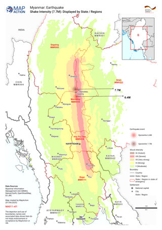
On 28 March 2025 at 12:50pm local time, Myanmar was hit by two powerful earthquakes. The first had a magnitude of 7.7, and the second, just 12 minutes later, had a magnitude of 6.4.
Causes
Myanmar is in a geologically active zone. This means it is a place where earthquakes are more likely to happen. The country sits in the middle of four tectonic plates: the Eurasian, Indian, Sunda, and a smaller plate called the Burma microplate. These plates are huge slabs of the Earth's crust that slowly move in different directions and at different speeds.

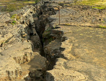
The recent earthquakes are believed to have happened because of a movement along the Sagaing Fault. This is a fault line that runs for about 1,200 km (or 746 miles) through the middle of Myanmar. The type of movement is called a strike-slip, where the plates slide past each other sideways. When they get stuck, pressure builds up and the release of that pressure can cause strong shaking.
Click National Geographical MapMaker to see more information about the plate movement.
Location
Both earthquakes struck either side of the city of Sagaing. The first earthquake’s epicentre was located 16km (10 miles) north-west of the city at a depth of 10km. The second epicentre was 18km south of Sagaing. The shakes were felt in six regions of Myanmar as well as the capital city May Pyi Taw, parts of India, China and Thailand.
Effects
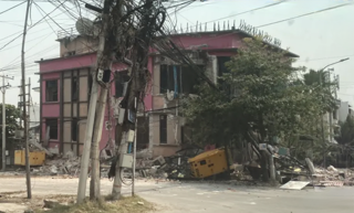
With an earthquake of this intensity - especially followed by another powerful one – serious damage is likely. At the time of writing, the earthquakes had claimed the lives of 3,564 people, injuring 5,012, with 210 still missing.
The earthquakes caused many buildings to collapse and damaged roads, especially in the south of the country including a route which connects Myanmar with Thailand. Tens of thousands of people were left without power, making the situation more difficult.
Over 1000 km away in Thailand, 21 people died as a result of the earthquakes, including 14 from a collapsed high-rise building.
Responses
After the earthquakes, aid began to arrive from nearby countries such as China, India, Malaysia, and Singapore. Other countries, including Russia, the European Union (EU), and the UK, also sent help. The World Health Organisation (WHO) sent 100 tonnes of medicines and supplies to support those on the ground administering medical care.
Some of the major relief efforts in terms of money and supplies:
- China sent $13.78 million worth of tents, blankets, and other emergency items.
- Hong Kong added another $3.8 million.
- The UK gave $12.9 million
- The EU gave $2.5 million.
- The USA donated $2 million.
- Non-governmental Organisations (NGOs) such as UNICEF, the Red Cross, and ActionAid also raised money to help survivors.
However, heavy rainfall hampered relief efforts in the earthquake hit areas of Sagaing, Mandalay and Kyaukse where unseasonal rains flooded roads and, combined with strong winds, damaged temporary shelters built for or by the survivors. With high temperatures and standing water, the outbreak of water borne diseases is a major concern to aid workers.
So that aid could reach those affected by the earthquakes, a 20-day ceasefire was announced between the military junta and rebel groups on 2 April. However, the UN Human Rights office received reports of at least 14 military attacks hindering the relief effort even further.
Further reading
Myanmar earthquakes updates, BBC, 28 March 2025 onwards
MapAction Myanmar Earthquake, March 2025 - various maps
What caused the powerful Myanmar and Thailand earthquake? Aljazeera, 28 March 2025
File nameFiles
File type
Size
Download
- Infographic

Myanmar earthquake infographic
A visual overview of the Myanmar earthquake 2025
- Case study
Greek earthquake swarm
Greece is one of Europe’s most earthquake-prone countries, experiencing an average of 25,000 earthquakes per year
- Case study

Volcanoes and earthquakes
Case studies of tectonic hazards which have happened since 2023.