
Introduction
Greece is one of Europe’s most earthquake-prone countries, experiencing an average of 25,000 earthquakes per year. However, the earthquake swarm that began on January 31, 2025, does not follow the typical seismic patterns of the region. These swarms have led to a 297% increase in the two-day average of recorded earthquakes.
An earthquake swarm is a sequence of mostly small tremors without a single, dominant mainshock, and it can last anywhere from days to months.
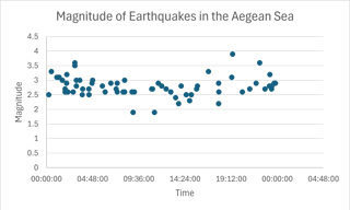
Between 9:00 on 20 February and 9:00 on 21 February, the Aristotle University of Thessaloniki (AUTH) Seismological Station recorded over 67 earthquakes within the 24-hour period, all occurring in the Aegean Sea.
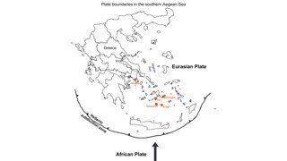
The earthquake swarm is mainly concentrated in the South Aegean Sea near the Cyclades Islands of Santorini, Amorgos, Anafi and Ios.
Tectonics
The Cyclades Islands are located north of the Hellenic subduction zone, where the African plate is moving northward beneath the Aegean sub-plate of the Eurasian plate at an average rate of 35mm per year. The earthquakes occurring during the swarm are relatively shallow, with an average focal depth of 7km. While a few tremors have reached a magnitude of 5.1, most have been low intensity, averaging a magnitude of 3.
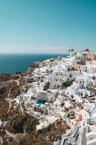
Santorini is geologically famous for the massive Minoan eruption circa 1600 BCE and thought to be the cause of the decline of the Minoan civilisation. This catastrophic volcanic event devastated much of Thera (modern-day Santorini), triggered a mega-tsunami that reached Crete’s northern coast - 110km away - and unleashed pyroclastic flows, mudflows, and lava fountains. Pumice from the eruption has been discovered as far away as Israel and Egypt. The caldera formed by this eruption is what shapes Santorini’s dramatic cliffs and stunning sea views, making it one of the most iconic tourist destinations in the world.
Effects
The ongoing earthquake swarm has led four Cycladic islands to declare a state of emergency. Santorini was the first island to do so on 6 February followed by Amorgos on 12 February, Anafi on 13 and Ios on 15 February.
Santorini, known for its iconic picture postcard images of Greece receives approximately 1.3 million tourists a year and has the highest revenue in the Cycladic Islands, generating €267.5 million in 2024 during the tourist high season (July - September).
With the state of emergency in place until at least 3 March, concerns are growing over the impact on tourism in 2025. Cruise ships that would typically stop in Santorini are already being rerouted to Crete and Syros, causing significant financial losses for the island.
Many residents have evacuated to Athens and other locations in Greece. Those who have left fear for the security of their homes and businesses from looting. Schools are closed on the islands and alternative provision for education is being discussed with children attending schools in other locations.
Landslides have also been reported on Santorini due to the tremors. In response, residents have been seen patrolling hazardous areas to prevent tourists from risking their safety for photos on the island’s cliffs.
The Greek government is offering financial aid to businesses for loss of earnings on Santorini and Amorgos, employees are set to receive €534 in compensation for loss of earnings between 1 February and 3 March.
Tracking and monitoring
Greece experiences thousands of seismic events each year and has developed extensive methods for monitoring activity. The country operates over 150 seismic monitoring stations, providing real-time data through the Seismic Network. This data is crucial for identifying patterns in seismic activity and has been used by scientists for centuries to better understand and predict tectonic movements.
For the first time, however, a team at the British Geological Survey is using machine learning algorithms to track the ongoing earthquake swarm. So far, this AI-driven approach has detected more seismic activity and identified early warning signs faster than traditional methods. The integration of AI in earthquake monitoring could mark a turning point in how such events are tracked and managed in the future.
Further reading
Tremors hitting Santorini reach new strength, BBC 10th February 2025
Santorini ongoing earthquake swarm, UNESCO 17th February 2025
File nameFiles
File type
Size
Download
