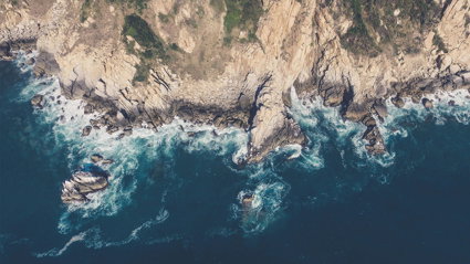
More than just a day at the seaside
This lesson aims to give students the opportunity to define what a coast is by looking at different types of coasts around the world. They will be introduced to different coastal features and their locations before considering how and why these features may change over time
Key questions
What is a coast?
The point where the land meets the sea or ocean
What do different coastal features look like?
The Coastal Features resource sheet for lesson one shows images of different coastal features. These features are: 1. Tombolo; 2. Beach; 3. Salt marsh; 4. Cave, Arch, Stack; 5. Bay; 6. Headland; 7. Cliff; 8. Spit; 9. Peninsula.
Tombolos, beaches, salt marshes and spits are formed as a result of deposition. Caves, arches and stacks, bays, headlands, cliffs and peninsulas are formed as a result of erosion. Go to the British Geographer website for details and diagrams of how each of these features are formed.
Why might coastal features change over time?
Coasts are dynamic systems which result in changes over time. Continuous erosion and or deposition will lead to coastal features changing over time.
How might coastal features change over time?
Erosion over time of a headland, for example, can lead to the development of a cave which can develop into an arch and eventually a stack and stump. Go to the British Geographer website for further information on these changes along with an over view of how other coastal features change over time.
Starter
Watch the PowerPoint What is a coast? You will see a number of different coasts from around the world. Work with a partner and use the evidence in the photographs to put together an answer to the question, what is a coast? Feedback your answer to the rest of the class and put everyone’s ideas together to create a class definition.
Main Activity
Your teacher will give you a blank world map and a resource sheet (Coastal Features) with nine images of different coastal features.
On the board will be a list of these features: beach; cave, arch, stack; cliff; tombolo, peninsula, spit, salt marsh, headland; bay. You have to see if you can guess which feature is which. Once correctly labelled, use an atlas to locate the different places for each feature on your blank map.
Next to the label, which should state the place name and coastal feature, you should draw a diagram to show that feature based on the image on the Coastal Features sheet.
Plenary
Choose one of the features you have looked at during today’s lesson. Think about how this feature might change over time? Would you expect it to look the same in 100 years’ time? Why do you think the feature you have chosen might look different?
File nameFiles
File type
Size
Download
