

Professional interest talks on demand

Digital twins in the transport sector #1
The Society and Ordnance Survey are collaborating on a lunchtime webinar series focusing on digital twins. This webinar will look at digital twins in the transport sector.

Geography in practice: digital twins for urban planning
The Society and Ordnance Survey are collaborating on a lunchtime webinar series focusing on digital twins. This webinar will look at digital twins for urban planning.

Geography in practice: the foundations of a digital twin
The Society and Ordnance Survey are collaborating on a lunchtime webinar series focusing on digital twins. This session focuses on the foundations of a digital twin.
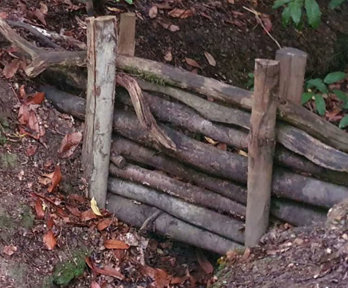
Geography in practice: learning from nature - supporting NFM design while enhancing river form and function
This webinar will focus on two main areas. First it will consider the breadth of NFM (Natural Flood Management) measures and their potential to interlink and emulate natural processes. Secondly focusing on one particularly popular NFM measure, the installation of ‘leaky barriers’.
Using GIS to survey habitats and measure improvements for Biodiversity Net Gain
Over the past year, data management firm EcoSpatial Solutions has been working with the Canal & River Trust to gather baseline data and measure improvements in biodiversity net gain (BNG) accurately in England and Wales.
Mapping underground Infrastructure through the National Underground Asset Register (NUAR)
This webinar will showcase how NUAR is set to revolutionise the way we manage underground infrastructure in the UK and its impact upon planning and land management by giving users access to data from all asset owners in a matter of second rather than days.

Using hydrometric sites and digital tools to manage England’s water resources
Join us to hear about how the Environment Agency is using a new digital service and their hydrometric network to manage England’s water resources.

Geography in practice: trajectories of neighbourhood deprivation in England
Join this webinar to explore how neighborhood deprivation measures in the UK identify vulnerable communities, guide resource allocation, and assess long-term changes using the Index of Deprivation across multiple time points. Discover insights from trajectory clusters and learn how these findings inform local authorities' efforts to reduce deprivation.
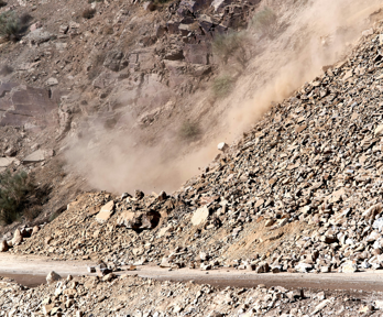
Multiscale landslide research at the British Geological Survey
During the sixth World Landslide Forum, 6 key thematic areas of landslide research were identified: Monitoring and early warning, modelling, hazard and risk assessment, mitigation techniques, triggering mechanisms, and climate change. This talk hosted by the British Geological Survey will cover the six key research areas, highlighting BGS activities and recent case studies.
Locally-led humanitarian planning and response … is this the end of international deployments?
This seminar explores fostering locally-led disaster responses, evaluating if current international policies support local leadership, and highlighting successful examples of collaborative programs with co-lead technical inputs.

Geography in practice: the ethnic group deprivation index for England and Wales
This is the first of two sessions designed to introduce the Ethnic Group Deprivation Index (EGDI) for England and Wales.

Geography in practice: analysing the Ethnic Group Deprivation Index
This second session on the Ethnic Group Deprivation Index (EGDI), includes a description of its creation, a demonstration of how the data can be used to understand ethnic inequalities in local areas, and hands on training on how to use the index.

Using the Ethnic Group Deprivation Index (EGDI) to inform decision making
The third Ethnic Group Deprivation Index (EGDI) session will outline some potential uses of the EGDI.

Geography in practice: biodiversity net gain, a new approach to an old problem
This webinar, led by John Cornell (Natural Environment Team Leader at Greater Cambridge Shared Planning), will examine biodiversity net gain (BNG) implementation in England, focusing on Greater Cambridge's experiences.
Applying the lessons from international disaster response to domestic major incidents
An expert panel will discuss the links, similarities, and differences between local and international policies and guidelines for disaster risk management and disaster response.

Ground truths: exploring the essentials of land referencing
This webinar, hosted by the Society of Land Referencers (SoLR), will introduce and explain the profession of Land Referencing, the processes involved within it, its significance to planning and development and how this relates to those with an interest in geography.

Geography in practice: the future for rural mobility
This webinar will explore the work of the University of Hertfordshire’s Smart Mobility Unit and Transport East who have been calling for research and future action into regional mobility.

Geography in practice: assessing river condition for biodiversity net gain
This webinar will look at how the River Condition Assessment method is being applied by environmental consultants and river managers in association with development projects that affect streams, rivers and canals.