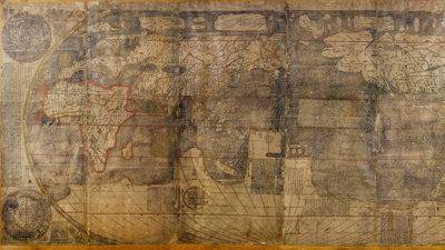
This large world map, which centres China and the Pacific, is an impressive example of global cultural and intellectual exchange. The map was the result of collaboration between Chinese scholars and artisans after interactions with Western-style maps and geographical ideas, particularly those brought to China by Jesuit priest Matteo Ricci (1552-1610).
It is one of only two known complete examples of this map made in c.1644. It shows five continents (Libya (Africa), Europe, Asia, America, and Magellanica) and four oceans (Atlantic, Indian, Pacific, and Arctic) with an accompanying geographical treatise, tables, and insets of the northern and southern hemispheres.
Cultural exchange between Ricci and Chinese scholars
Ricci arrived in China as a Jesuit missionary in 1583. He found a flourishing intellectual scene that he and his fellow missionaries considered to be as advanced as that of Europe.
The first of the maps made by Chinese scholars in interaction with Ricci were made in Zhaoqing in 1584, edited by Wang Pan, and in Nanjing in 1600, edited by Wu Zhongming, but they are no longer extant. The first to survive is a 1602 map made in Beijing on six panels and edited by Li Zhizao. Six complete examples of this map are known today. A larger, eight-panel map of 1603, also made in Beijing, edited by Li Yingshi, survives in two examples.
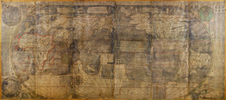
The map held by the Society is a later print of the 1602 map, produced in or after c. 1644, as it mentions the Qing (1644-1911), rather than the Ming (1368-1644), dynasty. This is one of two complete known examples of the c.1644 map and there is also a partial example in the Vatican library.
Traditionally, this map has been called a ‘Ricci map’ and Ricci’s influence and agency has been prioritised. This narrative marginalises non-European actors and disguises the many sites and stages of creation of a set of maps, of which this is one example.
More recent scholarship emphasises a multidirectional exchange of information and materials that resulted in a series of innovative world maps made all over East Asia and often without direct European influence.
How the map came into our Collections
This example of the Kunyu Wanguo Quantu was donated to the Society in 1858 by Dr William Lockhart, a missionary and surgeon who worked in China for 15 years. However, there seems to have been some confusion over its early identification, as the Geographical Magazine published an article in 1874 stating that no example of the map was known to survive (July 1, 1874, 147-8).
It was not identified until the early-twentieth century when examples began to be compared and analysed, including by Society Fellows and librarians. It has been on display in the Map Room since that part of Lowther Lodge was completed in 1930.
Valuable source of ongoing research and debate
Research on the map continues today. Scholars from around the world come to see the Kunyu Wanguo Quantu in our Map Room.
It is the subject of an ongoing conservation effort, so that future generations of students, Fellows, and members of the public can come to learn about knowledge networks that spanned the globe and connect us all.
Further readings
Akin, Alexander. East Asian Cartographic Print Culture: The Late Ming Publishing Boom and its Trans-Regional Connections. Amsterdam: Amsterdam University Press, 2021.
Cams, Mario and Elke Papelitzky, editors. Remapping the World in East Asia: Toward a Global History of the ‘Ricci Maps'. Honolulu: University of Hawai’i Press, 2024.
Zhang, Qiong. Making the New World Their Own: Chinese Encounters with Jesuit Science in the Age of Discovery. Leiden: Brill, 2015.