Mapping the world in the seventeenth century: the Hondius firm
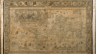
This impressive world map, on a Mercator projection, is the only known extant example of this work by Jodocus Hondius (1563-1612). It was purchased by the Society on 21 July 1919 to great fanfare from the Fellows. Today, it remains of immense interest to scholars of early modern mapping, Dutch cartography, and to those that are intrigued by ornate antique maps.
The map shows the world as it was understood by an early seventeenth-century mapmaker, Jodocus Hondius. Trained as an engraver, globe maker, and instrument maker, Hondius spent several years in London as a religious exile (1584-1593). While in London, he engraved the gores for Emery Molyneux’s globes, the first produced in England. Upon his return to the Low Countries, he set up shop in Amsterdam, where he specialised in producing atlases and wall maps like this one.

The map is also embellished with sea monsters, sailing ships, and elaborate cartouches. The grandest of these, in what is today Canada, show the continents portrayed by women, a trope that was common for centuries and usually implied Europe’s dominance over other continents. The decorations continue in the map’s borders, which feature views of cities and European perspectives on the dress and appearance of peoples from around the world.
An invaluable part of our Collections
The 1608 map in our Collections is a second state, or second version, of Hondius’ large wall map of the world. The first state was published in 1603 with a different dedication, cartouches, and border vignettes. It is also known in only one example and was sold in 1998 to a private US collection.
The map was initially lent to the Society by Charles Stanley Peach; its 12 sheets were already mounted and framed at that time. Peach very much wanted the Society to have the map, selling it for a cheap £75 on the condition that the Society neither sell or dispose of it.
The Society has done neither, seeing it was one of the gems of our cartographic collection, which numbers over one million items.
Further readings
Koeman, Cornelis, Günter Schilder, Marco van Egmond, and Peter van der Krogt. ‘Commercial Cartography and Map Production in the Low Countries, 1500–ca. 1672.’ In History of Cartography Volume Three (Part 2): Cartography in European Renaissance, edited by David Woodward, 1296-1383. Chicago: University of Chicago Press, 2007.
Zandvliet, Kees. Mapping for Money: Maps, Plans, and Topographic Paintings and Their Role in Dutch Overseas Expansion During the 16th and 17th Centuries. Amsterdam: Batavian Lion International, 1998.