Join us
Orange welcome sign that reads Royal Geographical Society with IBG.

Become a member and discover where geography can take you.

Join us

London-based British-Indian artist Hormazd Narielwalla has collaborated with the Society to create a new mural, Expanding Universe, a body of abstract work that will hang in the Map Room for the next five years.

The installation is part of a wider Society project considering the items on display around our building, ensuring that those selected not only better represent the range of our constituencies and the breadth of our work, but also make the building more welcoming.

Expanding Universe was developed after Hormazd’s research into the Society’s map collection and the artwork incorporates references from the Society’s historical archive including monsters, sea creatures and mythical characters popular in 15th century cartography.

Join Hormazd on a public tour of the building as he discusses his artwork and inspiration from the Society.

Venue information

This event will be held at The Royal Geographical Society (with IBG), 1 Kensington Gore, London, SW7 2AR.


Plan your visit to the Society and find more information about our venue, including our address, accessibility and transport links.

You may also be interested in...

  • ExhibitionFiennes and Burton navigate through rough sees in their Boston Whaler.

    Transglobe Expedition exhibition

    This exhibition showcases stunning photographs of the legendary Transglobe Expedition (1979–1982), captured by distinguished photographer Bryn Campbell.

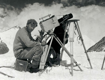
  • ExhibitionHistoric black and white photograph of two explorers taking photographs in a snowy mountainous environment.

    Everest through the lens

    Another chance to see the Society's exhibition marking the centenary of the early Everest expeditions. Explore how Captain John Noel's films shaped the public's imagination of Everest, while obscuring the vital role of local intermediaries.

  • ConferenceSatellite radar image (European Space Agency, Sentinel-1 sensor) processed to highlight areas of water (blue) near Maputo, Mozambique and overlain with roads (black).

    Uses of remote sensing in emergency and disaster management

    This symposium focuses on uses of remote sensing – from satellites through to drones, as well as crowdsensing and other geospatial data - for contingency planning, emergency management and disaster response.

Key Information

Open to all
19 February 2025, 2.00pm-3.00pm
Royal Geographical Society (with IBG)

In-person
Non-member £0.00, Member £0.00
Book Now